Transforming real-life locations into 3D models with tools like Google Maps can be an intriguing process. In this article, we'll guide you through the comprehensive steps to create your own 3D model effectively, enhancing your design toolkit with Homestyler.
Using Google Maps for 3D modeling presents endless opportunities for architects, designers, and enthusiasts alike. Have you ever considered how to convert a basic street view into an intricate virtual model? Let’s dive into the details!
Assembling Your Tools and Resources
The initial phase of building a 3D model leveraging Google Maps is to gather essential tools. You'll require software such as SketchUp, Blender, or a capable 3D modeling app like Homestyler. Which tool are you most comfortable with? Share your favorites in the comments!
Next, get accustomed to navigating Google Maps. Utilizing features such as the 3D perspective can significantly enhance your understanding of elevation, a key factor in accurate modeling. Did you know you can tilt the view to capture better angles? This really boosts your modeling precision.
Extracting Information from Google Maps
After your tools are set up, the next step involves extracting vital data from Google Maps. Tools such as Google Earth can provide you with detailed dimensions of buildings and landscapes.
Alternatively, capture screenshots of the area you wish to recreate, focusing on various angles. This data will become invaluable as you craft your model. Ready to delve into the creative zone? Let’s move on!
Constructing Your 3D Model
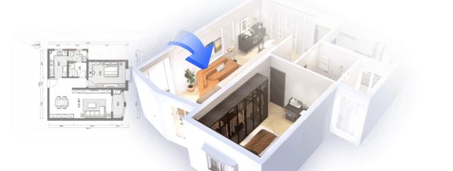
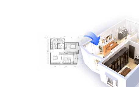
With references and tools at your disposal, it’s time to begin crafting your model. Utilize the software to trace over the screenshots or rely on the measurements from Google Earth.
Start by outlining the shapes of buildings, roads, and any prominent features. Following the rough layout, add details to the architecture. Have you considered implementing texture mapping? This step is crucial for bringing your model to life!
Rendering and Evaluating Your Model
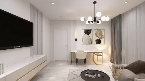
Once your model is built, rendering is essential to visualize it in a lifelike environment. Most modeling software, including Homestyler, provides rendering capabilities that allow you to manipulate lighting and shadows for a touch of realism.
When reviewing your model, think about making refinements based on the real-world data you collected from Google Maps. This is also an ideal moment to solicit feedback from colleagues. What are your impressions of the finished model? We welcome your thoughts!
FAQ
Q: Which tools serve best for generating 3D models from Google Maps? A: Software like SketchUp or Blender stands out due to their intuitive interfaces and ease of use.
Q: Can I directly incorporate Google Maps into my modeling software? A: While direct imports are not possible, obtaining screenshots and referencing detailed information is key to success.


Modern Rattan Fabric Upholstered Loveseat Sofa 3D Model

Minimalist Light Gray Fabric L-shaped Sectional Sofa 3D Model
Discover the ease of home design with Homestyler! This user-friendly platform features an intuitive online design tool, stunning 3D rendering, and a rich collection of design projects. Plus, you can enhance your skills with informative DIY video tutorials. Bring your dream space to life effortlessly!
Diseño ahora GRATIS